|
|
|
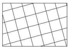
Kilometric grid (Lambert 1 - orientation : 15 degrees) |
|
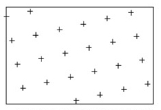
Geographic grid (Bonne) |
|
|
|
|
|
|
Re-projected kilometric grid (UTM strip 31 on Lambert 1 oriented 15 degrees) |
|
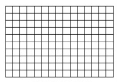
Regular grid |
A grid is a virtual cutting of the map used to locate entities easily. Starting from grids you can automatically create a drawing and retrieve indexes for texts or symbols.
There are two kinds of grids:
the regular grids, cut the workplane into equal rectangles.
the grids using a projection cut the map in either the meridians and the parallels of the Earth, or the lines of the kilometric system of the projection.
|
|
|
Kilometric grid (Lambert 1 - orientation : 15 degrees) |
|
Geographic grid (Bonne) |
|
|
|
|
|
|
Re-projected kilometric grid (UTM strip 31 on Lambert 1 oriented 15 degrees) |
|
Regular grid |
Each grid is limited by a rectangle. All the curves created to represent a grid are clipped by its bounding rectangle. A grid also manages an index system for texts and for symbols of the map located inside its border rectangle. The whole index of the map can be saved in a text file.
A file can contain several grids of different types.
WARNING:
In our programs we make a difference between the "virtual grid" which is a mathematical definition of a cutting of the plane (used to retrieve indexes) and the "grid drawing" which is a representation of a "virtual grid". Once you have automatically drawn a grid, the resulting curves and texts are not linked to the "virtual grid". They are just a graphical representation. So if you modify the "virtual grid" you have to generate its drawing again.
Please refer to the "Grids drawing" paragraph for more details.
Click Manage/Grids menu. The following panel is displayed:
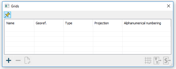
By default the list of grids is empty. This panel lets you manage all the grids of the document. Most of the actions done in this panel are applied to the selected grid.
Below is panel description:
|
Grid drawing wizard |
|
Exporting index for texts |
|
Exporting index for symbols |
For each grid all the following information are displayed:
"Name" : name of the grid.
"Georef." : geographic and kilometric grids must be always based on a georeferencing that has been defined in the file.
"Type" : three types of grid are available : regular, kilometric and geographic.
"Projection" : geographic and kilometric grids are defined according to a projection. This projection may be different than the one chosen to define the georeferencing, and a full secondary grid can be drawn.
"Alphanumerical numbering" : an alphanumerical system of index may be associated to a grid. This option is always activated in the case of a regular grid, but it can be disabled in the case of a geographic or a kilometric grid.
It is possible to save an index file using one of the available grids either for texts or symbols. This file will contain all such visible entities of the document located inside the limit and, for each of them, both vertical and horizontal indexes in the numbering system of the grid.
Other information can be saved, as the used type, the layer, the component and the notes associated to the indexed elements.
Index can be generated in LorikCartographer, LorikDBCartographer or LorikPublisher depending on spacing parameters defined during grids definition.
Each text of the document (flat text or text along a curve) has at least one index point. When it is edited, a green triangle is displayed at this point. It means that this point (this position) is taken into account during index file saving.
Concerning the symbols, the index point is the insertion point. Please refer to the corresponding paragraph in Graphical template chapter